Home · Walks & essays · Oxfordshire
Oxfordshire walk
The Ridgeway at Wayland’s Smithy: a short walk into deep time
A four-mile stretch of the Ridgeway National Trail to a Neolithic chambered long barrow, with notes on prehistory, weather and where to stop.
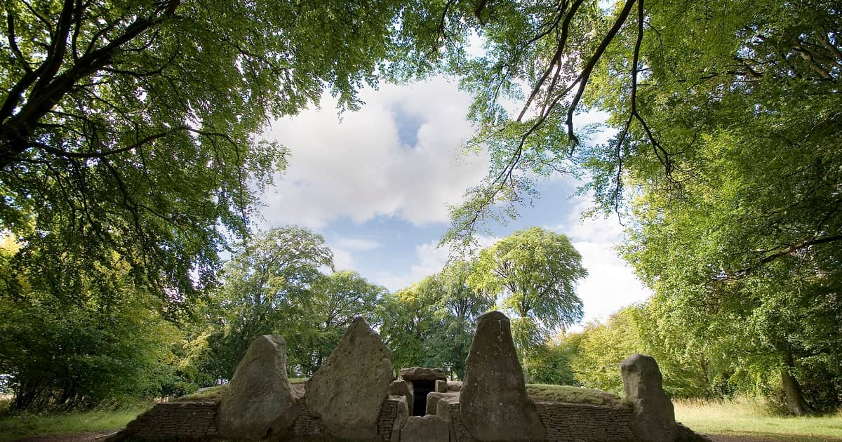

The Ridgeway is the oldest road in Britain still in use, or so it is often called. Whether or not that quite fits, people have been crossing the Berkshire and Oxfordshire downs along this chalk escarpment since before writing reached these islands. Now a National Trail, it runs for 87 miles along the high ground from Overton Hill in Wiltshire to Ivinghoe Beacon in Buckinghamshire, and the particular stretch I keep coming back to is the four miles around Wayland’s Smithy.
It is a short, mostly flat walk on open chalk track, with a Neolithic chambered long barrow in the middle of it. If I had to recommend a single piece of the Ridgeway for someone with half a day and a pair of trainers, this would be it.
The site
Wayland’s Smithy is a long, grass-covered mound set back a few yards from the Ridgeway, hidden in a small square of beech trees. It is one of the best-preserved Neolithic chambered long barrows in Britain. The entrance is a façade of standing stones at the south-east end, blackened by lichen, with a sealed stone passage beyond.
The site is in the care of English Heritage, which describes it as a Neolithic chambered long barrow, once believed to have been the home of Wayland, the Saxon god of metal working. Excavation in the 1960s found that 14 people were interred in an earlier burial structure between 3590 and 3550 BC, the earliest radiocarbon dates on the site. The present long barrow was built over the top of it about a century later.
The walk
I usually park at the small Ridgeway lay-by near Ashbury on the B4000 (postcode SN6 8NN gets you close). From there the Ridgeway runs east and west as a wide, firm chalk track. Walk south-east with the escarpment to your right. In a mile the track crosses a minor lane and climbs very gently through open downland.
After about a mile and a half, a small gate on the right leads into a grove of beech trees. The sudden shelter after open sky is one of the pleasures of the walk. The long barrow lies ahead on a rise. Walk round it before you look closely at the entrance; the shape of the mound is easier to read from the north end, where the stones do not distract.
Continue east along the Ridgeway for another mile and you will see the Uffington White Horse cut into the chalk below you. If time and legs permit, drop down onto the hill fort above the horse, Uffington Castle, Iron Age, and back up to the Ridgeway for the return. That makes the walk a little more than seven miles, mostly flat, on firm track.
The ground underfoot
The Ridgeway here is a wide, white chalk highway between hedges and open fields. In dry weather it is almost dusty. After heavy rain the surface puddles in the deep ruts cut by farm vehicles and, in places, by trail bikes; if you are not keen on mud, choose your season. The National Trail is well waymarked with a stylised acorn at junctions, so you do not really need a map to stay on it, though a map is useful for planning the loop and for the Horse.
A long memory
People have walked this line of chalk since the Neolithic. The barrow is older than Stonehenge in its earliest form. The horse is late Bronze Age or early Iron Age. The hill fort came later still. The Ridgeway itself, as a prehistoric routeway along the dry, well-drained chalk ridge, predates all of it and simply continued in use under every society that followed.
Standing on the escarpment with the Vale of the White Horse opening below you, it is not hard to imagine a stream of lives moving along this same line with reasons of their own. The site is the sort that rewards silence; if there are other people when you arrive, it is kind to wait, read the English Heritage board at the entrance, and give the stones a few minutes to be seen quietly.
Practical notes
- No fee and no gate at Wayland’s Smithy; the site is open at any reasonable time.
- Dogs welcome; keep them close in the barrow grove, the stones are low and easy to trip over.
- No toilets or refreshments on the Ridgeway here; the pub in Woolstone, below the horse, is the nearest option and keeps rural hours.
If you want more
For a walk of similar age but very different mood, see our piece on Avebury, where the Ridgeway officially begins on Overton Hill. For a map-reading warm-up before you come, our beginner’s guide to Ordnance Survey maps covers the symbols you will meet.
And whatever path you are on, the Countryside Code is as relevant on an Iron Age ridge as it is in a Surrey wood: close the gate, keep dogs close, leave the stones for the next walker.
A note on the seasons
The Ridgeway here walks well all year, but each season gives it a different character. Late spring is loud with skylarks over the chalk, and the fields below the escarpment are still green. High summer bleaches the track almost white and the beech grove at the barrow is a cool, welcome shade. Autumn is my favourite: the hedges are busy with sloes and haws, and the low light catches the chalk ridges in the fields. Winter, on a still day after a frost, can be startling, and on a windy day can be exposed and unforgiving. Carry more than you think you need in the short months.
Getting there without a car
Public transport to this stretch of the Ridgeway is thin but not impossible. The nearest main-line railway station is Didcot Parkway, with occasional local buses onwards to Wantage and Uffington; the service pattern shifts with each timetable change, so check a current operator before you set out. Walkers often combine the Ridgeway with a longer traverse from a station, carrying a packed lunch and picking up a taxi back from a village pub at the far end.