Home · Walks & essays · Wiltshire
Wiltshire walk
Avebury: a slow circle of the world’s largest stone ring
A reflective walk through the largest stone circle in the world and the Neolithic landscape around it, with notes on history, weather and tea stops.
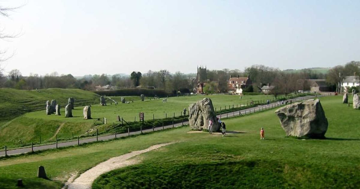

Stonehenge gets the coach parties. Avebury gets the sheep. The largest stone circle in the world sits on quiet ground in the Marlborough Downs, cut through by an ordinary village street, and you can walk into it from the pub car park. You can also touch the stones, which you cannot do at its famous neighbour.
This is a short, slow walk inside a very long memory. The circle and its outlying monuments are a Neolithic and Bronze Age landscape, made and remade across more than two thousand years. If you go on a weekday morning, you will mostly share it with jackdaws and sheep.
What you are looking at
Avebury is a henge: a round bank and ditch enclosing a flat space, with gaps for entrances. Inside the henge sit three stone circles, one very large outer ring and two smaller inner ones. The outer circle is the biggest in the world. The village of Avebury was built, over the centuries, right through the middle of it, so cottages and sarsens stand side by side.
The National Trust, which cares for the site today, describes it as the largest stone circle in the world with other monuments within it including a cove and two stone circles, part of the Stonehenge and Avebury World Heritage Site. The ceremonial landscape here was in active use, in its various forms, between roughly 3700 and 1600 BC.
The walk
From the main car park on the west side of the village, cross the lane and enter the south-west sector of the henge through a timber gate. The bank rises gently to your left and the ditch drops away sharply, much more sharply than photographs suggest. The grass is kept short by sheep and by the trust’s grazing partners, so the shape of the earthwork is clear in low sun.
Walk clockwise, inside the bank, around the outer circle. You will pass sarsens that are still standing, concrete markers where stones were broken up in later centuries, and places where the circle disappears beneath houses and a lane. Take your time; the path is quiet and the perspective changes every few paces.
At the south entrance, duck out of the henge and follow the lane south-east to pick up the West Kennet Avenue. This is a double row of stones that once ran for about a mile and a half from Avebury to the site known as the Sanctuary on Overton Hill. A section of it has been restored and is open to walk along. The field path is well-trodden; stay on the line to avoid trampling the shallow archaeology.
Where to stop
Back in the village the Red Lion pub sits inside the henge, one of very few in the country where you can drink a pint on a scheduled monument. Next door, the National Trust tea room keeps country hours and good cake. The Alexander Keiller Museum, named after the archaeologist who re-erected many of the stones in the 1930s, sits in the stable block of Avebury Manor and is worth half an hour before or after the walk.
A quiet suggestion
Go at the edges of the day. The stones are at their best when the light is low and the coaches are elsewhere. Even on a Saturday morning you can have whole quadrants of the henge to yourself before ten.
Weather and footing
The ground inside the henge is mown grass on clay-with-flints. It is firm in summer and sticky after rain. There is no shelter anywhere inside the circle, and the Marlborough Downs can turn a bright morning into a sideways shower before you have reached the Avenue. Carry a thin waterproof even in August. Boots are unnecessary; a pair of trainers with a tread will do, though you may regret anything suede.
A note on the history
Avebury was not built all at once. Radiocarbon dating points to the bank and ditch going up in the earlier Neolithic, with the great stone circle set inside it later, and the Avenue added later still. The complex was quarried for building stone in the medieval period and systematically broken up in the eighteenth century by villagers and a local landowner. Keiller’s twentieth-century work put many fallen stones back where excavation showed they had stood; smaller concrete markers show stones that were broken up and cannot be replaced.
If you want to go deeper into the prehistory of chalk country, the short companion walk on this site to the Ridgeway and Wayland’s Smithy picks up the same landscape a few miles to the north, along the chalk escarpment.
Getting there
By car, Avebury is signed from the A4 at Beckhampton and from the A4361 north of the village. The National Trust car park is on the west side and is pay-and-display for non-members. By bus, routes from Swindon and Devizes stop in the village on weekdays and some Saturdays; the service pattern changes, so check your local operator before you travel. Rail is some miles away at Pewsey or Swindon.
Reading the wider landscape
A map helps here, more than you might think. Without one, the henge is a fine thing to walk round, but you will miss the shape of the wider complex: Silbury Hill a mile to the south, the West Kennet Long Barrow on the ridge beyond it, the Sanctuary on Overton Hill at the far end of the Avenue. With an Ordnance Survey Explorer sheet open on a bench outside the pub, the Neolithic layout starts to click into place, and the walk takes on the proportions the people who built it intended.
Avebury rewards return visits. Nothing about the stones changes; the light does, and so does the mood. A still day in February, with frost on the top of the bank and the whole site to yourself, is a different place entirely from an August afternoon with the field mown close and the sky high overhead. If you can only come once, aim for a weekday outside the school holidays and come early.