Home · Walks & essays · North Yorkshire
Yorkshire walk
Malham Cove, Gordale Scar and the quiet pull of limestone country
A bright autumn walk across the famous Yorkshire Dales pavement above Malham Cove, with notes on glacial history, meltwater and Ice Age plants.
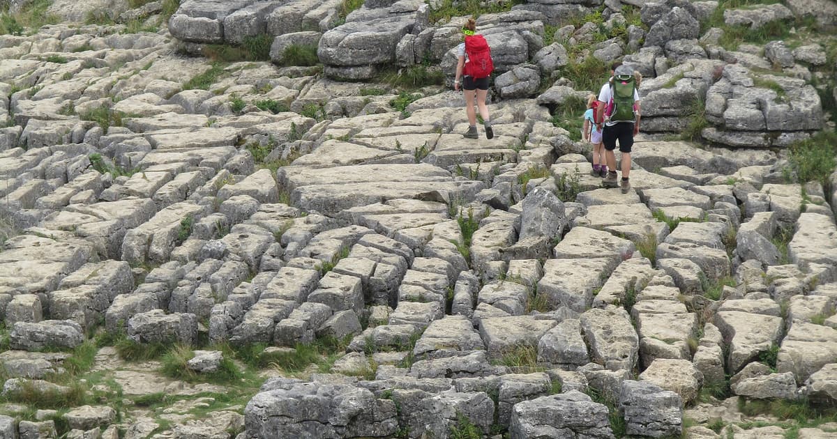

Malham sits in a soft pocket of the Yorkshire Dales National Park. The village is small; the geology around it is very large indeed. A classic short circuit links two of the most arresting features in upland England, Malham Cove and Gordale Scar, with a quiet pavement walk across the top that is half footpath and half geology lesson.
This walk works in any season. In October, the light slides low across the limestone and the bracken turns copper. In high summer, the pavement is popular and the parking fills early. A still, grey November morning, when the water has risen in the beck, is my favourite.
What you are walking through
Malham Cove is a curved limestone cliff, about 80 metres high, left behind when a great waterfall stopped flowing at the end of the last Ice Age. The water now comes out as Malham Beck at the foot of the cliff and runs down into the village. On top of the cove is one of the finest examples of limestone pavement in Britain, a flat surface of ‘clints’ (the stone blocks) split by ‘grikes’ (the vertical fissures between them), scoured by ice and etched since by rain.
The pavement above the cove is a Site of Special Scientific Interest and part of the Yorkshire Dales National Park. The grikes hold rare limestone-loving ferns and small flowering plants; some of them are legally protected from collection. The surface is as dangerous as it looks after rain, so slow boots and small steps are the sensible approach.
The route
Start from the village car park at the north end of Malham. Follow the signed path along the beck upstream, through meadows and alongside a drystone wall, towards the cove. The cliff grows in the view until it fills it. At the base, a stone step path climbs the east side to the top of the pavement, this is the hard part of the walk, short and steep.
Onto the pavement. Take your time crossing it: look at the plants in the grikes, not just at your feet. Follow the trod east across the plateau, then drop down into Watlowes, a dry limestone valley once cut by the same vanished river that carved the cove. From Watlowes, turn north-east to pick up Gordale Beck.
Gordale Scar itself is a different animal from the cove, a narrow, high-walled ravine with twin waterfalls tumbling through it. The famous scrambling route up the tufa to the right of the lower fall is doable in dry weather if you are confident on wet rock, and genuinely unpleasant in winter. If you prefer to keep both hands for sandwiches, there is a path that climbs out of the valley back onto the plateau without any scramble; signs make the options clear.
From the top of the Scar, follow the track west back across the pavement and down the stone steps the way you came. The whole circuit is around seven miles, with one steep climb and one steep drop. Allow four hours to walk it properly.
Where to stop
Malham village has a few pubs and a small cafe. They keep upland hours, they are busier at midday and quieter after four, and some close an afternoon a week off-season. There is a water point by the car park. The National Park Centre, when open, has a good set of information boards that put the geology into plain English.
A few practical notes
- Carry water: once you leave the beck there is no reliable source on the plateau.
- The pavement is slippery in wet weather. Keep weight over your feet.
- Grikes can be ankle-deep. Watch children, and watch your own stride.
A long memory
At the end of the last glaciation, meltwater from a shrinking ice cap poured off this landscape in volumes we cannot easily picture. The stream that made Malham Cove stopped flowing because the ice that fed it stopped melting. The valley it left behind, dry today, still runs across the top of the plateau, you walk through it. The relationship between what you see and what happened here is unusually legible; you can read the Ice Age with your feet.
If you want to extend the walk, a longer loop takes in Malham Tarn, the highest natural lake in England, and a stretch of the Pennine Way. That is a day with an early start and good boots. For another short Yorkshire Dales walk written in this spirit, we are working on an entry on Aysgarth, which will appear in the walks index when it is ready.
Dogs, children, buses
Dogs are welcome but should stay on a lead on the pavement and near sheep; grikes are a real hazard to small paws. Children who are confident on uneven ground will enjoy the geology; small children may need a steadying hand on the stone steps below the cove. A seasonal bus runs to Malham from Skipton, with timetables that shrink in winter, check your local operator a few days before.
For a plainer introduction to what the symbols on your map mean, see our companion piece on reading an Ordnance Survey map.
What to look for on the pavement
Three things reward a few minutes of attention on top of the cove. First, the depth of the grikes. Some are no deeper than your boot; others plunge down a metre or more, with soil, moss and ferns thriving in the shelter. Second, the direction of the scouring. Faint grooves on the surface of the clints run along the line of the ancient ice, pointing roughly south. Third, the plant life: hart’s-tongue fern, herb robert, limestone-loving bedstraws. In late spring, bird’s-eye primrose shows blue in the damp hollows.